 Tropical Storm Alberto at peak intensity | |||||||||||||||||||||||||
|---|---|---|---|---|---|---|---|---|---|---|---|---|---|---|---|---|---|---|---|---|---|---|---|---|---|
| Formed | May 19, 2012 | ||||||||||||||||||||||||
| Dissipated | May 22, 2012 | ||||||||||||||||||||||||
| Highest Winds | 60 mph (95 km/h) | ||||||||||||||||||||||||
| Lowest Pressure | 995 mbar | ||||||||||||||||||||||||
| Damages | Minimal | ||||||||||||||||||||||||
| Casualties | 0 | ||||||||||||||||||||||||
| Areas affected | The Carolina Coast | ||||||||||||||||||||||||
2012 Atlantic hurricane season | |||||||||||||||||||||||||
Tropical Storm Alberto was the first tropical storm of the 2012 Atlantic hurricane season. Forming on May 19 near the US East Coast south of North Carolina, the storm quickly reached peak intensity of 60 mph (95 km/h) as it moved generally to the southwest. The storm shifted back to the east and then to the north as it gradually weakened before dissipating on May 22. Alberto was the first named pre-season storm to develop in the Atlantic since Tropical Storm Arthur in May 2008. Additionally, the storm had the earliest formation date of any tropical or subtropical system in the Atlantic basin since Subtropical Storm Andrea in May 2007.
While it remained offshore for its entire lifetime, Alberto generated large swells that prompted several offshore rescues and dropped light rain on the coast.
Meteorological history[]
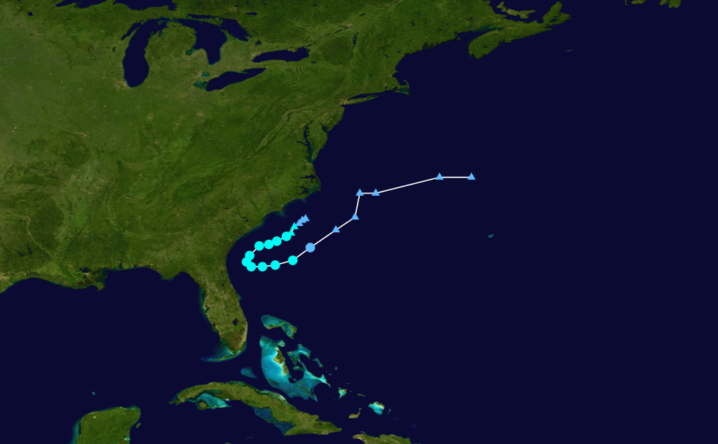
Storm track
On May 18, a cold front had moved off the United States East Coast and a non-tropical low pressure system had formed east of the South Carolina coast. The low pressure area detached from the parent cold front and remained generally stationary the next day as it interacted with a mid and upper level trough. Due to the organized nature of the system, the National Hurricane Center assesed a low 20% chance of the system becoming a tropical or subtropical system and designated it as 93L.INVEST the same day. The system quickly organized throughout the day, with convection increasing near the circulation center. Soon, the low pressure system gained sufficient organization, and at 2100 UTC, the storm was designated as Tropical Storm Alberto, skipping the tropical depression status and becoming the first named storm of the 2012 Atlantic hurricane season.
At the time, Alberto was situated in weak steering currents and model data did not have a fine consensus. Despite being over the Gulf Stream, Alberto was not expected to strengthen much due to the presence of dry air. While Alberto was originally estimated with winds of 50 mph (80 km/h), a ship report later on May 19 suggested stronger winds, and it is believed Alberto reached peak intensity with winds of 60 mph (95 km/h) and a minimum pressure of 995 mbar based off of the report. However, the NHC stated in a system discussion that night that radar presentation of Alberto suggested otherwise. As such, they had determined the wind speed of Alberto remained the same as earlier stated in a compromise between the weak radar presentation and the otherwise strong report from the ship near the center of Alberto.
Tropical Storm Alberto maintained its intensity the next day. However, the storm encountered strong wind shear that afternoon and dry air which caused some weakeneing. The center of circulation soon became displaced away from Alberto's strongest convection. A strong blocking anticyclone positioned over the eastern United States that had caused Alberto's general movement to the southwest moved eastwards and Alberto began its anticipated curve to the northeast on May 20. At the end of the day, Alberto had gradually weakened down to a minimal tropical storm.
Alberto continued to weaken for the duration of May 21. The system completed its counter-clockwise curve and began to move to the east and northeast. While for much of the day Dvorak satellite estimates had suggested that the storm had already weakened down to tropical depression strength, a Hurricane Hunter flight into Alberto discovered that it maintained its minimal tropical storm strength. However by the end of the day Alberto had become extremely sheared, with convection restricted to only the northeast quadrant of the system. Due to its ragged satellite appearance, the NHC downgraded the storm into a tropical depression. Alberto continued to weaken into the next day before finally dissipating on May 22, although its remnant circulation remained for a few hours before being absorbed by a cold front.
Preparations and impact[]
As Alberto neared the East Coast, the National Hurricane Center issued a tropical storm watch for a region of coastline extending from the Savannah River to the mouth of the South Santee River in South Carolina. The watch was discontinued after Alberto did not cause coastal tropical storm impacts and shifted away from the coast. In addition several tourist cruises were cancelled due to the presence of Alberto.
Rain totals from Alberto's outer rainbands peaked at around a quarter of an inch in the Charleston, South Carolina region. Other areas of the East Coast only measured minimal amounts of rain. In Folly Beach, South Carolina, Alberto was reported to have caused minor beach erosion, with losses of up to 3 feet of sand reported. Strong rip currents and high surf of up to 5 feet prompted several rescue operations.