
|
This page uses content from Wikipedia. The original article was at en:wikipedia:South Atlantic tropical cyclone. The list of authors can be seen in the page history. As with Hurricane Wiki, the text of Wikipedia is available under the GNU Free Documentation License. |
A South Atlantic tropical cyclone is a rare cyclone that occurs in the south half of the Atlantic Ocean. These are rare due to high wind shear and lack of space for the cyclones to form. If there was to be a 'Hurricane Season' or 'Cyclone Season' it would last from November to April, with March being its peak. These cyclones would be given identifiers SL, for example INVEST 90SL or Tropical Depression 1-SL.
Tropical or Subtropical cyclones
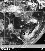
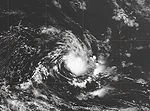
Subtropical Cyclone of March 1974
Similar to the later formation of Catarina, a strong dipole-blocking structure (or Rex blocking) persisted for nine and a half days over the western South Atlantic Ocean in late March 1974, which decreased wind shear across the region. A low pressure area developed over the Amazon basin, and intensified as it moved southeastward over open waters, establishing a very large closed circulation. Deep convection increased near the center, and banding features began developing. The system resembled a subtropical cyclone, and there were hints of a warm-core. It was unable to intensify further, due to the weakening of the ridge component of the blocking -which led to shear increasing- and water temperatures decreasing. Unlike Catarina, the system maintained a southeast motion throughout its duration.
Angola Tropical Storm of 1991
On April 10, 1991, a weak tropical storm formed in the eastern South Atlantic, recorded by weather satellites off the coast of Angola. It formed on April 10, and dissipated two days later, drifting west-southwestward from where it formed. Of the few South Atlantic tropical cyclones that have been recorded, this was the only one in the eastern portion of the South Atlantic.
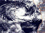
Tropical Cyclone of January 2004
A small area of convection developed on a trough of low pressure in mid January off Brazil. It organized and appeared to become a tropical depression on January 18. The next morning, it had a small CDO and well-defined bands, and the system, either a weak tropical storm or a strong tropical depression, likely reached its peak. Located 150 nautical miles (280 km) southeast of Salvador, Brazil, it weakened as upper level shear, typical for the basin, prevailed. The depression moved inland on the 20th as a circulation devoid of convection, and dissipated the next day over Brazil, where it caused heavy rains and flooding.
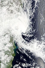
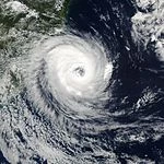
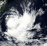
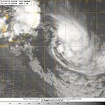
Cyclone Catarina
Cyclone Catarina was an extraordinarily rare tropical cyclone, forming in the southern Atlantic Ocean in March 2004. Just after becoming a hurricane, it hit the southern coast of Brazil in the state of Santa Catarina on the evening of March 28, with winds estimated near 155 kilometres per hour (96 mph), making it a Category 2-equivalent on the Saffir-Simpson Hurricane Scale. The cyclone killed 3 to 10 people and caused millions of dollars in damage in Brazil.
At the time, the Brazilians were taken completely by surprise, and were at first in utter disbelief that an actual cyclone could have formed in the South Atlantic despite the insistence of the Miami Hurricane Center otherwise. Later, they were convinced, and adopted the name "Catarina" for the storm, after Santa Catarina state. This event is considered by meteorologists to be a nearly once-in-a-lifetime occurrence.
Tropical Storm of February 2006
A small area of convection 600 miles southeast of Rio de Janeiro was tracked into an area of relatively low shear and marginal 26°C waters on February 23, 2006. The wave had deep convection, was able to form a closed LLC and had 35 mi/h (56 km/h) winds as measured by Quikscat on February 24, 2006. These characteristics were operationally recognized for three hours before high shear began to tear the system apart, just short of the six hours required to be officially declared a tropical depression. The storm was estimated at have peaked in intensity with winds of 65 mph (100 km/h), equivalent to a strong tropical storm, early on February 23. While under study, the system was referred to as 90L Invest. The shear would eventually cause the system to dissipate later that night.
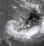
Subtropical Storm of January 2009
A cold-core mid to upper-level trough in phase with a low-level warm-core low formed a system over Uruguay and Rio Grande do Sul state in Brazil and moved eastward into the South Atlantic. Winds exceeded 54 knots on the coast of Uruguay and extreme southern Rio Grande do Sul. The storm produced rainfall in 24 hours of 300 mm or more in some locations of Rocha (Uruguay) and southern Rio Grande do Sul. The weather station owned by MetSul Weather Center in Morro Redondo, Southern Brazil, recorded 278.2 mm in a 24-hour period. Fourteen deaths and thousands of evacuees are attributed to the storm with an emergency declared in four cities.
Tropical Storm Anita
On March 8 2010, a previously extratropical cyclone developed tropical characteristics and was classified as a subtropical cyclone off the coast of southern Brazil. The following day, the United States Naval Research Laboratory began monitoring the system as a system of interest under the designation of 90Q. The National Hurricane Center also began monitoring the system as Low SL90. During the afternoon of March 9, the system had attained an intensity of 55 km/h (35 mph) and a barometric pressure of 1000 hPa (mbar). It was declared a tropical storm on March 10 and became extratropical late on March 12. Anita's accumulated cyclone energy was estimated at 2.0525 by the Florida State University. There was no damage associated to the storm, except high sea in the coasts of Rio Grande do Sul and Santa Catarina. Post mortem, the cyclone was given the name "Anita" by private and public weather centers from Southern Brazil.
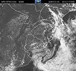
Subtropical Storm of November 2010
On November 16, a cold-core mid to upper-level trough in phase with a low-level warm-core low formed a system over Uruguay and Rio Grande do Sul state in Brazil and moved southeastward into the South Atlantic, where it slightly deepened. The system brought locally heavy rains in southern Brazil and northeast of Uruguay that exceeded 200 milimeters in a few hours in some locations of Southern Rio Grande do Sul northwest of Pelotas. Damages and flooding were observed in Cerrito, São Lourenço do Sul and Pedro Osório. Bañado de Pajas, departament of Cerro Largo in Uruguay, recorded 240 mm of rain. Then, it started to drift southeastward, over open waters of the South Atlantic, where it gradually weakened. The subtropical cyclone became a weak trough on November 19, according to the CPTEC. The low pressure system that originated the subtropical cyclone favored hail storms that affected dozens of cities in Southern Brazil, mainly in Rio Grande do Sul state, on November 15. Over a dozen towns declared emergency due to the damages. In some places, the hail accumulated 30 cm (one foot) and could be seen in the fields even four days after the storm.
Subtropical Storm Arani
Early on March 14 2011, the Navy Hydrographic Center-Brazilian Navy (SMM), in coordination with the National Institute of Meteorology, were monitoring an organizing area of convection near the southeast coast of Brazil. Later that day a low pressure area developed just east of Vitória, Espírito Santo, and by 1200 UTC, the system organized into a subtropical depression, located about 140 km (90 mi) east of Campos dos Goytacazes.
Guided by a trough and a weak ridge to its north, the system moved slowly southeastward over an area of warm waters, intensifying into Subtropical Cyclone Arani on March 15, as named by the Brazilian Navy Hydrographic Center. The storm was classified subtropical, due to the convection being located east of the center. On March 16, Arani began experiencing 25 knots of wind shear due to the another frontal system bumping it from behind.